Special Studies
Highlights:
In 2024, CCBWQA completed and embarked on several special studies to better understand conditions in the watershed and opportunities to reduce pollutant loading to the Reservoir.
Special studies included:
- Watershed Plan Update: In 2024, CCBWQA continued working on an update of its 2012 Watershed Plan. This effort integrated findings from the HSPF watershed modeling scenarios linked to the Reservoir model, and will be completed in 2025.
- Wetlands Harvesting Pilot Project: In 2024, CCBWQA completed year four of a six-year project to cut and dispose of wetland vegetation to reduce phosphorus and nitrogen from being carried to Cherry Creek Reservoir after the plants decay.
- BMP Effectiveness Study: In 2022, Regulation 72 stormwater requirements were “modernized” to be consistent with the current state of the practice for reducing pollutant loads from stormwater. As a companion effort, CCBWQA began a study to synthesize the most current information on the expected effectiveness of stormwater BMPs (also known as stormwater control measures). Wright Water Engineers submitted a draft report to the TAC MS4 Subcommittee in December 2024; the report will be finalized in the spring of 2025 after input from CCBWQA.
- Receiving Pervious Area Study:CCBWQA partnered with SEMSWA and the Mile High Flood District to develop a more quantitative understanding of volume reduction benefits of receiving pervious areas such as grass buffers, grass swales and other landscape areas. By reducing runoff volumes through use of receiving pervious areas, pollutant loads can be reduced, as well as channel erosion. Use of receiving pervious areas is a key principle of low-impact development and green infrastructure approaches to development. Wright Water Engineers completed a final report summarizing the results of this study in 2024, which is now available here.
- USACE Water Level Management Pilot Study:CCBWQA provided a letter of support to the USACE related to a pilot project beginning in 2024 that the USACE is undertaking to strategically manage water levels in the Reservoir to improve water quality during the summer months. CCBWQA will also provide data sharing to support this effort.
Useful Links
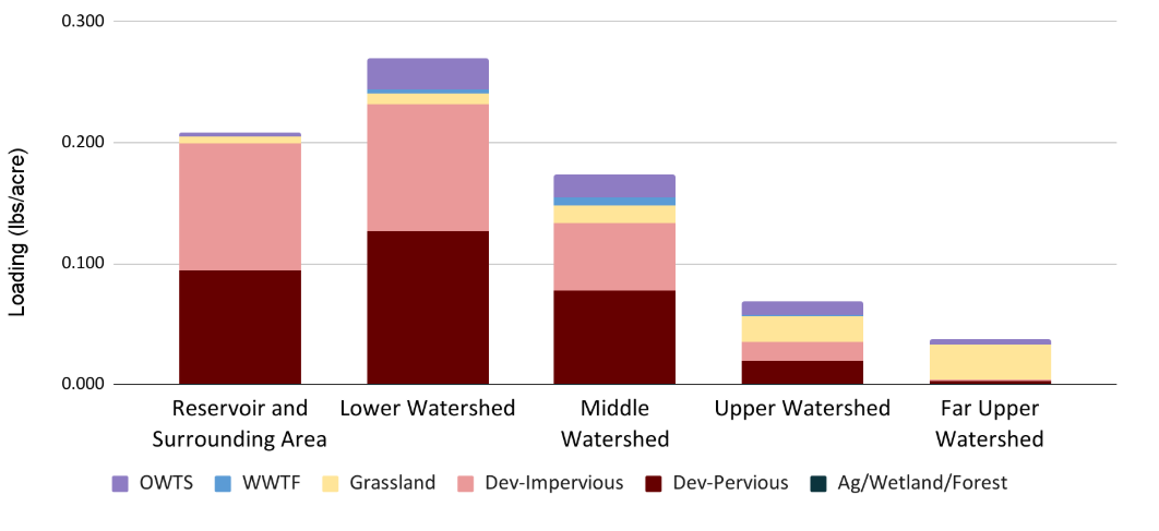
Watershed Plan Relative Source Contributions
The Watershed Plan will leverage monitoring and modeling results to target high impact locations and project types.
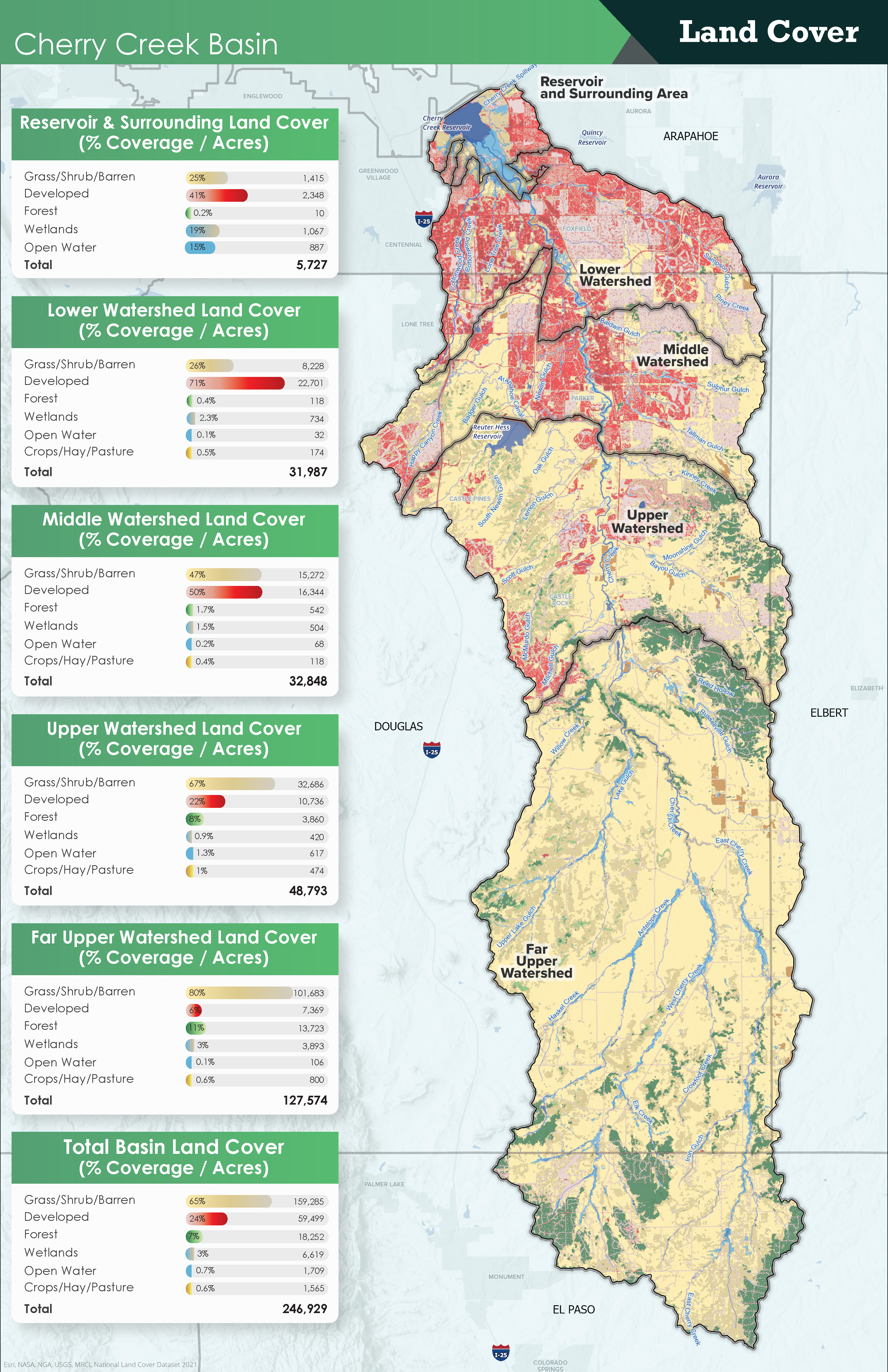
Click to see larger version of map
CCBWQA is applying modeling results broken out by subbasins to examine where and what sources contribute the most to nutrient loading. For example, the graph below illustrates how Developed areas have the highest phosphorus source contributions per acre, especially in the Reservoir area, low and middle watershed. Grasslands are a more dominant source upstream in the watershed, but have low loading rates over all. Onsite water treatment systems (OWTS) increase upstream but have low loading. Waste water treatment facilities (WWTF) contribute a very small percentage and Agriculture, Forest and Wetlands impacts are negligible.